Location
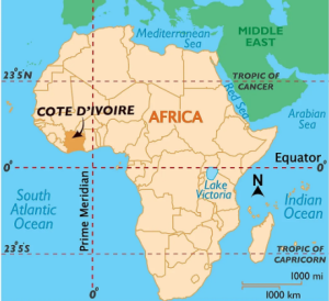
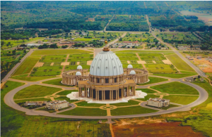
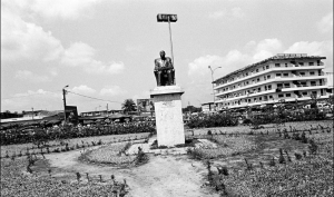
Côte d’Ivoire is a coastal country in West Africa. Abidjan serves as the de facto capital. Yamoussoukro has been designated as the administrative center. The nation is well-known for its beach resorts, tropical jungles, and legacy of French colonialism. The concrete La He Pyramid, which resembles a ziggurat, and St. Paul’s Cathedral, a cascading building tied to a massive cross, are examples of contemporary landmarks. Banco National Park is a rainforest reserve with hiking paths located to the north of the CBD (Appiah & Gates, 2019). The Ivory Coast is bordered to the north by Mali and Burkina Faso, to the east by Ghana, to the south by the Gulf of Guinea, to the southwest by Liberia, and to the northwest by Guinea.
A high savannah that is typically 300 meters above sea level makes up the northern part of the country. The earth climbs steadily away from the coast (Baten, 2016). The majority of the western border between Liberia and Guinea is made up of mountain ranges, the tallest of which, Mount Nimba (1,752 m; also called the Nimba Mountains), is a part of the Mount Nimba Strict Nature Reserve. This is also the location of the intersection of the borders of the three nations.
Population and size
Based on the revised estimates provided in the Global Population Prospects for the year 2022, the overall population of ivory cost was 27,478,249 in the year 2021. The country had a surface area of 322,460 km2 (124,502 mi2) and a net shore of 515 km.
There are four distinct natural regions in the nation. The eastern part of the coastline is littered by lagoons, while the shoreline itself is made up of narrow strips of land no wider than 40 miles (64 km). The Equatorial Forest, which until a century ago formed a continuous expanse more than 200 km wide, is located outside the coastline limit (Baten, 2016). It is presently confined to a roughly triangular region, with the border with Liberia forming the base and the apex immediately north of Abidjan.
The forest that has been partially cleared for plantations makes up the cultivated forest area to the east of this triangle, especially along the Ghanaian border and in the Buake region. The fourth region, Northern Savannah, is made up of an open plateau with few people living on hence making it good for livestock rearing. A portion of this region—approximately 4,500 square miles (11,650 square kilometers)—has been designated as Comoe National Park. (Baten, 2016).
Languages
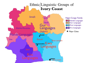
Ivory Coast is a multilingual nation where 78 different languages are currently spoken. However, French, which was adopted during the colonial era, is now the official language. This language is taught in schools and is used widely throughout the nation. The Kwa, Atlantic, Mande, and Volta languages are the four main streams of the Niger-Congo language used by Ivorian people. The four cultural regions of the nation are closely matched by the linguistic region. The most extensively used languages in the South are Agni and Baule, both Kwa languages.
The Mande and Senov language variations can be heard almost everywhere in the South, but are more prevalent in the North. The majority of Ivorians speak two or more of the continent’s languages fluently, and there is no one African language that is spoken by the majority of the continent’s inhabitants (Dinerstein, 2017). French is spoken more frequently by men than by women in both business and educational settings. The majority of madrasas in the north teach Arabic, which is spoken by immigrants from Lebanon and Syria. Despite the fact that English is taught in high schools and at the National University of Côte d’Ivoire, many Ivory Coasters do not want to speak it.
The indigenous population of the nation makes up just over 70% of the total. Numerous indigenous languages are spoken across Côte d’Ivoire as a result of this variety. The four regional language families of the northwest Mande family, the north Senufo family, the southwest Kuru family, and the southeast Kwa family can be used to classify these languages (Grantham & Duncan, 2020). Researchers estimate that 3 million individuals speak immigrant languages in addition to these indigenous languages. Other indigenous African languages or languages from non-African nations like Vietnam, Spain, Lebanon, etc. could be considered among these immigrant languages.
Climate
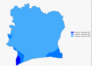
The weather is transitional between equatorial and tropical in terms of temperature and humidity, and it is typically warm and muggy. Temperature alone is not enough to differentiate the seasons; rainfall and the direction the wind is blowing are far more telling. The cycle of the seasons that is connected with heat and cold further from the equator is determined by the apparent shift of the sun from south to north which is followed by the maritime and continental air masses, and these air masses influence the climate.
In reaction to the motion of the sun, the warm air mass that originates in the ocean moves more to the north over the country of Côte d’Ivoire throughout the first half of the year. A low pressure belt, also known as an intertropical front, travels in front of it, bringing warm air, rain, and winds that are mostly from the southwest. The solar cycle begins to turn counterclockwise about the middle of the year, which causes the continental air mass to travel southward over the country and makes it possible for the dry northeast harmattan to take the lead. The winds at the surface are light and seldom reach speeds of more than fifteen to twenty kilometers per hour.
History
The history of this country is rich with events that mainly form the basis of what it is today. The first Europeans to reach the coast were Portuguese explorers at the beginning of the 16th century. Trading for gold, ivory, and pepper began. The first missionaries made their initial encounter with the French in 1637. The region was overrun by Akan people fleeing the Asante Empire in the 1750s (now Ghana) (Lipski, 2015). Around Sakasso, they established the Kingdom of Baule. The French trading post was created in 1830 after the French Admiral Bouet-Wilome acquired a protectorate. The limits of the French colony of Ivory Coast were agreed upon with Liberia and the Gold Coast at the end of the 19th century.
Laurent Gbagbo was elected president of the People’s Front of Côte d’Ivoire (FPI) in October 2000 after General Robert Guay established a government of national unity. Since Alassane Ouattara was disqualified from the election, Guay has only had Gbagbo as the sole opposition party. Abidjan’s military coup in 2002 caused political rifts in the nation. The north is Muslim, whereas the south is mostly dominated by Christians. Fighting was stopped by peace talks, but the nation remained split and for a number of reasons, President Gbagbo refrained from calling fresh elections since 2005.
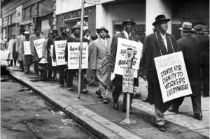
Côte d’Ivoire joined the French West African Federation in 1904 and was placed under the Third Republic’s control as an overseas colony (Dinerstein, 2017). Charles de Gaulle’s Free France took control of the region in 1943, displacing Vichy. At about the same time, Félix Houphouet-Syndicate Boigny’s Agricole African (SAA, African Agricultural Syndicate), which represented African farmers and landowners, was founded.